Thursday, February 14, 2013

Irvington – Jewel of Indy’s Eastside

Irvington is a historic neighborhood on Indianapolis’ eastside. The beautiful homes of Irvington, mostly built from the 1880s to the 1930s, housed residents who worked a wide variety of professions. Grocery store owners, journalists, writers, artists, railroad officials, engineers from Indianapolis’ once thriving auto factories, academics, politicians and military officials.

It was also the home of Butler University from 1875 to 1928.

The winding, tree-lined streets make Irvington one of the most scenic neighborhoods in Indianapolis.

The Bona Thompson Memorial Center served as Butler's library from 1901 through 1928 and is now home to Irvington's historic archives. It’s the only surviving building from the old Butler University campus. The center houses a permanent collection of the Irvington Group of Artists, including such names as William Forsyth, Clifton Wheeler, Dorothy Morlan and Helen Hibben, of whom some were contemporaries of such Hoosier Group greats as T.C. Steele. It also features rotating exhibits of contemporary work by central Indiana artists, historical displays, dramatic readings, book talks and guided tours of Irvington. Below are items featured in the center.


The foyer to the Bona Thompson Memorial Center.


A model of Butler’s campus circa 1914. It’s a shame these beautiful structures didn’t survive. It’s been said that IPS was offered the campus to form Irvington High School. It would have been much like Arsenal Technical High School in having a large campus with multiple structures. IPS turned down the offer and the buildings were razed in the 1920s and a neighborhood built on the site.


One of the rooms displaying art in the center.

A vintage railroad flagman’s hat. The Pennsylvania Railroad used to run through the middle of Irvington. The community had even had a train station. Hawthorne Yards is just to the south of Irvington and at one time employed many of the area’s residents.


A caboose lantern found along the Pennsylvania Railroad tracks.


Howe High School memorabilia.


Sunday, October 21, 2012

Ohio River Autumn

A drive along the Ohio River in Southern Indiana is especially beautiful during fall. This is a just west of Madison in mid-October.

Friday, October 14, 2011

Narrow-leaved purple coneflower

Purple coneflowers growing along a rural road in southeastern Indiana. Legend has it that native American discovered medicinal purposes for the flower. It’s said to prevent the flu and respiratory diseases. Native Americans learned of the properties of the plant by observing elk seeking out the flower and consuming them when sick or wounded.  Native Americans identified the plants as "elk root"

Moscow, Indiana's rebuilt covered bridge.

On June 3, 2008 an F3 tornado ripped through Moscow, Indiana and the town's historic covered bridge was torn from its piers and thrown into to creek bed of the Big Flatrock River. Volunteers came together to rebuild the bridge at Moscow. This is how the bridge looked in October of 2011.

Monday, May 2, 2011

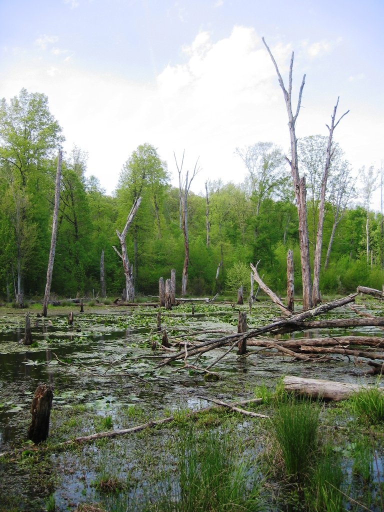
Central Indiana's Swampy Woodlands

Central Indiana was settled much later than southern Indiana. One of the biggest reasons was the swampy woodlands that dominated the area. For much of the spring and early summer in pre-settlement days this is the way central Indiana looked. In addition to making travel difficult, the stagnant swamps promoted mosquito-born diseases. Today few areas of the swamp woodlands remain. Most areas have been drained over the years by a large network of ditches.
Swampy woodlands dominated central Indiana in pre-settlement days.

Sunday, November 14, 2010

The Headwaters of the Wabash

The headwaters of the Wabash River.
The mighty Wabash is just a tiny stream at
its source south of Fort Recovery, Ohio.
The Wabash River is the largest river in Indiana. Many songs and poems have been written about the lazy river that meanders its way from northeast to southwest across the state. Numerous towns sprang up on its banks; the river providing both a reliable water supply and an early mode of transportation for crops, produce and livestock produced in its fertile valley.

The Wabash is without doubt Indiana’s river, even though its mighty waters start modestly in the state of Ohio. This is a photo of the headwaters of the Wabash taken at its source just south of Fort Recovery, Ohio.

While Hoosiers will always claim the Wabash their own, we should offer thanks to our eastern neighbors for giving us such a great gift.

Friday, November 5, 2010

Indiana’s High Point: Hoosier Hill

Perhaps one of the more humorous places to visit in Indiana is Hoosier Hill, the highest point in Indiana. Before you break out your climbing gear you should know that you can drive your car right up to a little parking spot just a few feet away from the highest point in the state of Indiana. There’s a short path that leads to a picnic table where you can take in the glorious views.

The truth is there are no views because Indiana’s high point is in a small patch of woods and it only rises a few feet above the surrounding countryside. If you’re a high pointer you can easily visit Ohio’s highest point just east of Bellefontaine, only about 80 miles east of here.

To get to Indiana’s high point take Highway 227 north out of Richmond, Indiana, about 13 miles to County Road 1100S. Turn left (west), go to the first road Elliott Rd.and turn left (south) again. The little patch of woods you see on the right-hand side of the road is where Hoosier Hill is located. There’s a small parking lane just on the southern part of the woods patch.

Be sure to sign the visitors register. There are humorous quotes in the book, things like – “We made it. What a climb!” or “Can’t stay long- forgot oxygen mask.”
This is what you’ll see at the summit of Hoosier Hill.

The “spectacular” view from the parking lane of Hoosier Hill.

Tuesday, November 2, 2010

Wilbur Wright’s Birthplace

The Wilbur Wright birthplace home near Millville, Indiana.
In a sparsely populated area of East Central Indiana, in the midst of vast stretches of corn and soybean fields, you’ll find the birthplace of Wilbur Wright near Millville, Indiana. The house pictured here is a replica. The original farm house burned long ago. Alongside Wright’s birthplace you’ll find an excellent museum documenting Wright’s youth and the life of him and his brother Orville, culminating in the first controlled, sustained powered flights on December 17, 1903 at Kitty Hawk, North Carolina. I love this area of Indiana. The rural county roads are narrow and look very old. You’ll see many old farms and houses from the turn of the century. It also happens to be the highest part of Indiana with elevations running 1100 to over 1200 feet.

Friday, October 29, 2010

Hidden Gem: Pine Hills Nature Preserve

I consider myself well traveled in the state of Indiana. From the Indiana Dunes to the Falls of the Ohio, from Hoosier Hill’s “dizzying” 1,257 feet to the lowlands of Posey County, I thought I’d covered the bases in the Hoosier State. Five minutes into my first hike into Pine Hills Nature Preserve I knew I had missed one of the most remarkable scenic wonders Indiana has to offer.

I’ve been to the popular Shades State Park dozens of times. How could I have missed the equally interesting geographic features of Pine Hills right next door?

For one thing Pine Hills has only been a nature preserve since 1969. While 41 years sounds like a long time, it takes generations of visitation for a park to really become part of people’s collective consciousness. Another factor is the tucked away Pine Hills is overshadowed by the sheer popularity of the nearby Shades and Turkey Run State Parks.

Pine Hills is a quick hike (maybe an hour, possibly two if you really take in the scenery) with breathtaking views around every corner. The big feature of the nature preserve is the Devil’s Backbone. This is the one trail that is somewhat challenging and if you’re scared of heights it could be intimidating.

Overall I rate Pine Hills as one of Indiana’s best-kept secrets and definitely worth a visit. As a bonus there’s also no entry fee, a good thing in these challenging economic times.


The Slide is a steeply banked wall of rock carved out over many thousands of years by the creek below. Check out the pine tree growing on just a thin crust of dirt covering the rock. That’s one thing that constantly amazed me about Pine Hills, trees growing on seemingly next to no topsoil at all.

The Devil’s Backbone seen from below. The unique ridge was formed by two creeks on either side that formed an extremely narrow and steep plateau.

It almost looks man made, but it’s not. Looking out to the Devil’s Backbone. Walking the narrow ledge with 75-100 feet on either side is not for the faint of heart, but the view from the top is worth the effort.

Honeycomb Rock’s scenic overhang with pine trees clinging to the edge. One of the many wonders of Pine Hills Nature Preserve.

One side of the Devil’s Backbone. Note the small pine tree growing on just the smallest of overhangs. You wonder how large that tree will actually get on such a small footing.


Saturday, October 23, 2010

Crawfordsville’s Main Street Plaza

The Main Street Plaza in Crawfordsville.
The Plaza in heart of downtown Crawfordsville, Indiana, is a focal point for community activities. On any given day you might hear a band or chamber orchestra playing, see arts on display or a variety of other activities.

Crawfordsville is a wonderfully walkable downtown with attractive buildings, beautiful public spaces, historical landmarks and some nice local restaurants, not to mention the nearby campus of Wabash University.

If you’re looking for a place to spend a day walking and enjoying the flavor of a small town Crawfordsville is a nice choice.

Wednesday, October 20, 2010

Indiana University’s Colorful Campus

To me one of the most pleasant autumn afternoon walks in the state is taking a stroll around the campus of Indiana University in Bloomington. The beautiful architecture of the buildings, the immaculate maintenance of the grounds, the wonderful color of the trees and the vibrant activity of the campus make a perfect combination. Actually I.U. is a great place to visit anytime of the year, but the colors of autumn put it on the top of my list. It varies, but peak colors in Bloomington usually start in mid-October and run through early November.

Saturday, October 16, 2010

Sugar Creek in Winter

In the summertime Sugar Creek in West Central Indiana is filled with rafters, canoeists and kayakers, but in the winter the beautiful creek is has nothing but the occasional duck or ice chunk floating downstream. Here is a winter view of Sugar Creek after a fresh snow.

Friday, October 15, 2010

Medora Brick Plant Ruins

This is a 2004 photo of the old Medora Brick Plant.
This brick plant was built in 1906 with the surrounding hills
of Southern Indiana supplying a ready supply of clay.
This is a 2004 photo of the old Medora Brick Plant. This brick plant was built in 1906 with the surrounding hills of Southern Indiana supplying a ready supply of clay. Road paving with bricks was popular in this era, but when other materials started being used for roads in the 1920s the plant experienced a downturn. The plant changed owners and began producing building bricks. It’s said that many of the buildings at Purdue University, University of Kentucky, and University of Louisville utilize bricks produced here.

Even though looking at these ruins it would seem the plant has been closed for decades, surprisingly it was in production through 1992. I haven’t been to the site for years, but it is decaying fast. Many former employees and their survivors hope that the site will be preserved. The Historic Landmarks Foundation put the brick works on the list of Indiana's 10 Most Endangered sites.

Thursday, October 14, 2010

Brown County Colors - Oct. 14, 2010

Still a little early and the drought hasn't helped. The colors are, so far, pretty muted.


Wednesday, October 13, 2010

Kids in the “Kid’s Cave”

A guide points out formations in Southern Indiana’s Marengo Cave to a couple of young visitors. It’s appropriate that kids enjoy the cave since the cave was discovered by children playing in the woods back in the 1880s. Marengo Cave has been a tourist attraction ever since.

Tuesday, October 12, 2010

Autumn at Cataract Falls

Cataract Falls is a favorite destination in Owen County, Indiana. There are two sets of waterfalls on Mill Creek. The upper falls are slightly taller than the lower.

Autumn is a great time to visit the falls, not only for the colors, but water flow is low enough to walk under the falls and get a close-up look of the interesting rock bed that make up the creek bottom. Visit the falls after a good rain to watch an impressive flow of water tumble over the falls. In the winter the falls sometimes freeze and form a unique stationary frozen waterfall.

Friday, October 8, 2010

Portland Arch and Fall Creek Gorge

A nice daytrip from Indianapolis or Chicago is the combination of the Portland Arch and Fall Creek Gorge (known by locals as The Potholes).

Portland Arch
Portland Arch
Portland Arch is a beautiful sandstone gorge and natural bridge formed by water eroding an archway under a large sandstone hill. While the Arch is the focal point, hiking the scenic gorge almost makes you feel like you’re in southern Utah instead of western Indiana.

The hike from the parking lot to the arch only takes about 5-10 minutes. If you continue on the trail you’ll follow the gorge and eventually make a loop back to the main parking lot. You might want to drive a quarter mile down the road from the main parking lot and there’s another smaller lot and trailhead that leads to another loop trail that follows a shallower section of the gorge.

Fall Creek Gorge (The Potholes)
Only 17 miles north of Portland Arch is a lesser known natural feature called Fall Creek Gorge, better know as The Potholes.

Finding The Potholes is a bit tricky. Take Hwy. 41 North. 4.4 miles north of Attica turn right (north) on Potholes Rd. Go 1.7 miles on the gravel road and look for the parking lot on the left just before the bridge.

The Potholes
The Potholes are literally big holes in the sandstone creek bed ranging from about two to six feet across and up to four or five feet deep. When I visited the area was in the third month of a major drought so there wasn’t much water running through the creek, but locals told me tubing down the steep creek descent is a popular pastime.

I felt luck to be there during the drought since it allowed me to walk the creek bed and get a close look at the giant potholes. The creek holding The Potholes also has a series of small waterfalls in it’s descent into the gorge. Even in the drought the waterfalls had water flowing.

My neighbor’s dog was with me on the trip and as we walked the creek bed he slipped into one of the potholes. He enjoyed the dip and scrambled out and had a nice shake to dry off. He then proceeded to play in the creek for the next 15 minutes. If you’re going to try to walk the creek bed I’d recommend leaving the cell phone and camera in your car. You’ll be wading ankle high one minute and then slip into a three-foot deep pothole the next.

You can easily take in both the Portland Arch and The Potholes in the span of four or five hours.

Wednesday, October 6, 2010

Adams Mill

Adams Mill
A few years ago we took the grandkids and a couple of their friends on a daytrip up to Wolf Park up near Battle Ground, Indiana. Just as an aside we decided to swing by Adams Mill to check it out and I’m glad we did.

As it turned out it was a hot and sunny day and the wolves, coyotes and foxes at Wolf Park were lazily taking it easy in the shade and we saw very little of them on the guided tour around the facility.

The kids, on the other hand, loved Adams Mill. It’s in a deeply wooded area, which made it a lot cooler on the hot summer day. We all enjoyed going through the old mill and the kids had a great time playing around the creek’s small waterfall. It helped that a couple of local dogs were hanging out and were friendly and played with the kids.

If you’re in the Lafayette area Adams Mill is a great place to visit. I would imagine it will be especially picturesque during autumn colors.

If you’re lucky one of the dogs owned by nearby farmers will come over and hang out while you’re visiting Adams Mill.

Indiana’s Stonehenge

Browning Mountain, which rises majestically over the ghost town of Elkinsville, Indiana, holds one of the biggest mysteries in the forests of Southern Indiana. Atop Browning Mountain (it’s actually Browning Hill, but the locals call it mountain so I will as well) are a group of giant box-shaped rocks, some as big as a car. Most of the giant slabs of stone are strewn somewhat randomly, but others are arranged in a circle leading to speculation that this was an ancient sacred meeting place for Native Americans.

There are so many legends about what some people call Indiana’s Stonehenge that it’s become a popular hiking destination in spite of being in a remote and somewhat hard to reach area of the southern Brown County.

Here are some of the legends of Browning Mountain’s giant stones:

n   These are limestone slabs not native to the area and somehow these huge slabs of rock, which  must weigh many tons, were brought up by ancient peoples from where the limestone is found nearly 90 miles away.
n   The stones are an ancient outdoor temple built atop the mountain.
n   Early settlers attempted to quarry the stone, but the quarrying was plagued by accidents, workers were killed and equipment broke down leading to belief by settlers that the mountain and the stones were protected by an Indian spirit watcher and further attempts to quarry the stone were abandoned.
n   Certain stones are laid out to line up perfectly to earth’s equinox.
n   Native American groups to this day meet on Browning Mountain for ceremonial services.
n   A group of scientist from South America came to the site to try to understand how the stones got to the top of the mountain and went away with more questions than answers.

Adding to the mystery are a few small ponds near the site of the giant stones.

If you’d like to visit Browning Mountain and Indiana’s Stonehenge bring your hiking boots, and some water and perhaps energy bars. It’s a steep and fairly long hike to the top of the mountain, which stands at 920 feet.


View Larger Map


Stones arranged in a circle to form an outdoor ceremonial area.

Some of the giant slabs of rocks that make up Indiana’s Stonehenge
atop the legendary Browning Mountain.

Paw Paw Marsh

Paw Paw Marsh in May of 2005
The Hoosier National Forest around French Lick, Indiana, is one of the most remote parts of the state. There are no interstates nearby (although unfortunately that will change with the I-69 extension) and the area is sparsely populated.

One weekend while visiting French Lick my wife and I looked on the map and saw Paw Paw Marsh. The Indiana Atlas and Gazetter actually had the location wrong.

The correct GPS location of the parking lot for the Marsh is Latitude: 38°34'34.31"N, Longitude 86°44'47.35"W.

Paw Paw Marsh is a unique little area – a flooded area of forest where dead trees and water plants give ample perch to birds of all variety.

This is a photo of the Marsh I took when we visited there in 2005.